You think this is bad? Scientists warn Britain is about to get hit with BLOOD RAIN as a Saharan red dust cloud sweeps from Europe across the UK
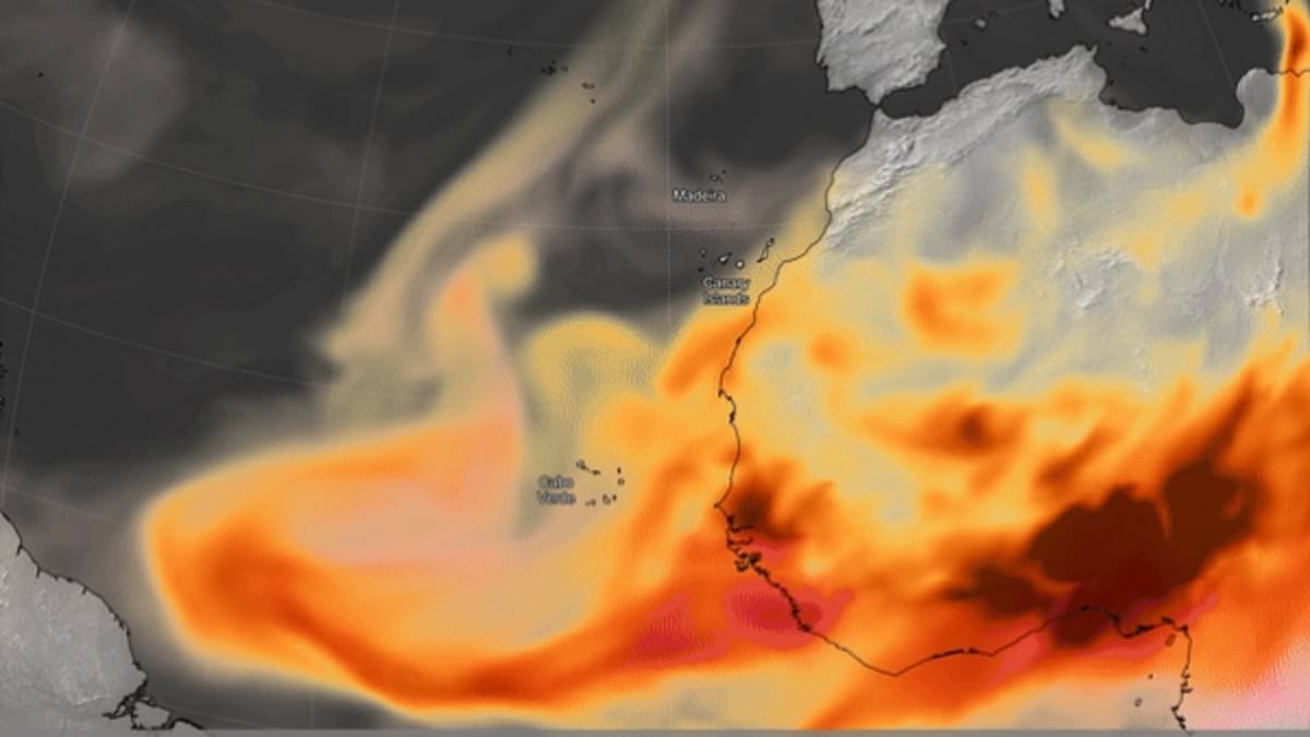
The rain in the UK seems to have been never–ending – with some regions experiencing showers every single day this year. Now scientists have warned that things are going to get even worse. Britain is about to be hit with showers of 'blood rain', according to experts from the Copernicus Atmosphere Monitoring Service (CAMS).This is thanks to a plume of red Saharan dust, which is currently sweeping over Europe towards the UK.When this dust mixes with Britain's persistent rain, the precipitation will take on a distinctive reddish colour – creating a phenomenon known as 'blood rain'. Despite its alarming appearance, experts say there is no reason to be concerned by this sudden change.The most dramatic consequence will likely be a thin film of dust left on cars and exposed surfaces once the rain has dried. Mark Parrington, Senior Scientist at CAMS, told the Daily Mail: 'Our latest forecast indicates that it will mostly pass over southern England and the Channel at higher altitudes in the atmosphere but may result in some wet deposition at ground level if it mixes with weather forecasts also showing some rain.' Britain is about to be hit with showers of 'blood rain', according to experts from the Copernicus Atmosphere Monitoring Service (CAMS). This is thanks to a plume of red Saharan dust, which is currently sweeping over Europe towards the UK When this dust mixes with Britain's persistent rain, the precipitation will take on a distinctive reddish colour – creating a phenomenon known as 'blood rain'. Pictured: blood rain in 2022CAMS is tracking the large plume of aerosols as it makes its way across the North Atlantic. The plume is largely made up of Saharan dust, with some smoke from seasonal biomass burning in Equatorial Africa. As in other parts of the world, the wind can blow strongly over deserts – whipping up dust and sand high into the sky. If the winds in the upper part of the atmosphere are blowing north, the dust can be carried as far as the UK.Once it is lifted from the ground by strong winds, clouds of dust can reach very high altitudes and be transported worldwide, covering thousands of miles.While it might sound intimidating, Mr Parrington reassures that this is actually something that happens fairly often. 'Large–scale outflow of aerosols to the North Atlantic is not uncommon at this time of year, with seasonal biomass burning in Equatorial Africa typically reaching its peak between January and March, and Calima winds transporting Saharan dust over the ocean,' he explained. 'The high intensity of this particular episode is notable as our forecasts show a plume reaching northwestern parts of Europe.' According to CAMS, the dust will likely arrive over the UK on Tuesday, where it will combine with the rain to form blood rain While red skies and blood rain might sound rather apocalyptic, the only likely lasting impact will be on carsAccording to CAMS, the dust will likely arrive over the UK on Tuesday, where it will combine with the rain to form blood rain. 'It looks likely to pass over in a couple of hours on Tuesday afternoon,' Mr Parrington said. 'Our latest forecast runs to the end of Tuesday but there is some indication there may be more crossing southern England on Wednesday.'Alongside the red rain, the dust could also leave the skies themselves looking red. 'An aerosol optical depth value of 1 typically means hazy skies, and the values in the plume are relatively high,' Mr Parrington said. 'So it could cause more reddish/orange skies during Tuesday evening.'While red skies and blood rain might sound rather apocalyptic, the only likely lasting impact will be on cars. 'It is possible that there could be some deposition to the ground which could leave some dusty residue on cars and windows as it passes over,' Mr Parrington added. Alongside the red rain, the dust could also leave the skies themselves looking red. Pictured: a slightly 'off-colour' sky seen above Sheerness, Kent in 2022The news comes shortly after the Met Office warned the wet weather could last until mid–March. Sarah Davies, Head of Energy and Environment at the Met Office said: 'Wet weather has persisted for many areas over the past few weeks, with repeated Atlantic low pressure systems leaving ground conditions particularly saturated across southern parts of the UK.'While it is likely to remain changeable over the next few weeks, with further wet weather at times, the focus for the wettest conditions is expected to shift to western hills, where we would normally expect it at this time of year.'However, given some areas elsewhere remain sensitive following recent rain, any further spells of rain as we head into early spring has a higher chance of causing some impacts than normal for this type of setup.' What is blood rain? As in other parts of the world, the wind can blow strongly over deserts – whipping up dust and sand high into the sky. If the winds in the upper part of the atmosphere are blowing north, the dust can be carried as far as the UK.Once it is lifted from the ground by strong winds, clouds of dust can reach very high altitudes and be transported worldwide, covering thousands of miles.In order for the dust to get from up in the sky down to the ground, you need something to wash it out of the sky – rain. As raindrops fall, they collect particles of dust on the way down. Then when the raindrops land on something and eventually evaporate, they leave behind a layer of dust.Saharan dust is relatively common in the UK often happening several times a year when big dust storms in the Sahara coincide with southerly wind patterns. In certain weather situations, Saharan dust can also affect air pollution and pollution levels.Source: Met Office