Ireland weather: Met Eireann pinpoint when warmth ends with wintry conditions and 15 degree drop
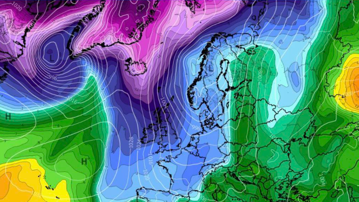
While the warm and mild weather is due to last all weekend, as we move into next week, things are due to take a major turn with wintry showers and possible thundery conditionsIreland has been enjoying some mild weather other the past few days, with people across the country soaking up the warmest days of 2026 so far.However, these mild conditions are not expected to last. While spring has sprung, there will be a dip in temperatures from next week, with wintry showers and with a chance of thunder from Tuesday, according to Met Eireann.While temperatures have reached a mild 16 degrees this weekend, the thermostats will drop as low as 1 degrees midweek next week - a huge drop of 15 degrees.Met Eireann's latest forecast also shows the dramatic change in conditions from Tuesday night into Wednesday. Tuesday night will remain windy and showery with some showers turning wintry and lowest temperatures of 1 to 4 degrees.Alan O'Reilly, meteorologist behind the popular Carlow Weather social media pages, also said we can expect much cooler conditions next week. "Colder next week with some wintry showers. Bad news for the heating bills," he said, sharing images from weather models showing a temperature dip from Wednesday.Here is Met Eireann's forecast:SaturdayAny lingering mist and fog will continue to clear, though it may stay stubborn in some coastal parts. It will be a dry day for most with spells of hazy sunshine and highest temperatures of 11 to 16 degrees. Overnight, cloud will increase from the northwest with a little light rain and drizzle, and lowest temperatures will range from 0 to 6 degrees, coldest in the south with a touch of frost.SundayGenerally cloudy at first with a little rain and drizzle moving southeastwards, followed by a clearance to mostly dry weather with sunny spells extending from the northwest. Highest temperatures will reach 9 to 14 degrees. Sunday night will be dry with a mix of cloud and clear spells and lowest temperatures of 1 to 6 degrees.MondayA largely dry day for most with some hazy spells of sunshine, though it will become increasingly cloudy with light rain moving into the northwest later in the evening. Highest temperatures will range from 9 to 13 degrees. Monday night will be breezy and cloudy with outbreaks of rain and lowest temperatures of 6 to 9 degrees.TuesdayCloudy for a time with outbreaks of rain, heavy at times, clearing southeastwards by the afternoon to sunny spells and widespread showers of hail and potential thunder. Highest temperatures will be 9 to 12 degrees. Tuesday night will remain windy and showery with some showers turning wintry and lowest temperatures of 1 to 4 degrees.WednesdayA windy and showery day with heavy and potentially wintry showers, especially during the morning and again later. While there will be some sunny spells, it will feel much colder due to significant wind chill, with highest temperatures of only 7 to 9 degrees in fresh to strong northwest winds.Want to see more of the stories you love from Dublin Live? Making us your preferred source on Google means you’ll get more of our exclusives, top stories and must-read content straight away. To add Dublin Live as a preferred source, simply click here.