When will it snow next in the UK after Storm Goretti?
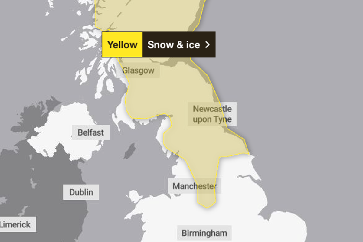
Get the free Morning Headlines email for news from our reporters across the worldSign up to our free Morning Headlines emailSign up to our free Morning Headlines emailParts of the UK are buried under heavy snow and ice after what officials say could be the “worst snowfall in a decade”.Storm Goretti swept across the Channel to the UK on Thursday evening and into Friday, battering the Isles of Scilly and Cornwall with hurricane-force winds and covering much of the UK with snow.open image in galleryWeather warnings are in place for Saturday (Met Office)The Met Office issued a number of weather warnings for snow and ice across much of the country on Friday, as people face travel disruption and schools have closed. A yellow warning for rain is also in place across much of the east of England.Storm Goretti is expected to slowly edge away towards the end of Friday. But it won’t be long until the UK sees its next spell of snow.Three yellow snow and ice warnings have been extended into Saturday by the Met Office. The warnings cover Scotland and large swathes of Northern England, the Midlands, and parts of the South West, as well as Wales and Northern Ireland.open image in galleryParts of Wales have seen heavy snowfall, with icy conditions expected on Saturday (PA)A yellow warning for snow and ice comes into force from midday on Friday and has been extended until 3pm on Saturday, with further snowfall possible across parts of northern England and much of Scotland, while a widespread risk of ice is expected to cause disruption.A separate yellow warning for ice will cover large parts of England and Wales from midday on Friday until midday on Saturday as partially thawed snow refreezes, accompanied by wintry showers and freezing fog.In Northern Ireland, a yellow warning for snow and ice will come into force from 5pm on Friday and run until 11am on Saturday, with the Met Office warning of icy patches and some hill snow.A yellow weather warning for snow and ice has also been issued across Scotland, the north of England, and parts of the Midlands for Sunday. The Met Office said parts of the affected area could see as much as 30cm of snow, with 5cm likely more widely.open image in galleryMore weather warnings are in place in Scotland and northern England for Sunday (Met Office)Forecasters say the band of snow will move across the warning area on Sunday morning, with high ground once again most likely to see the most intense snowfall.Temperatures are expected to hover largely above freezing, at around 2C in most of the affected areas.People are being urged to plan travel routes ahead of time as snow is set to bring “possible delays” that could leave people and cars stranded. The Met Office has also told residents in the affected areas to prepare for potential power cuts, which it said could also impact mobile phone coverage.TodayStorm Goretti will slowly edge away, but rain and some snow will continue across the east of England. Elsewhere, a mixture of clear and sunny spells with a scattering of wintry showers in places. Windy and feeling cold.open image in galleryAround 250 schools across the UK are closed due to snow (PA)TonightRain and sleet will slowly clear in the east of England, with wintry showers continuing elsewhere, mostly along the coastal region. Another cold night with widespread frost and ice. Winds will ease further east.SaturdaySome wintry showers for parts of eastern England and Scotland. Dry with variable cloud elsewhere with frost inland unlikely to clear during the day. Much lighter winds than of late.Outlook for Sunday to TuesdayFurther wet and windy weather moving east through Sunday, with some hill snow in the north. Can also be windy here. Milder for all by Monday and into Tuesday.