First Alert: Light snow through this evening
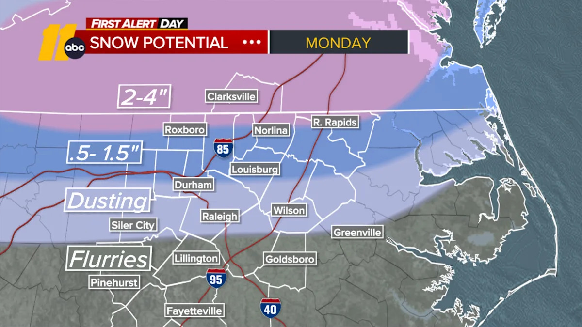
First Alert-Winter Weather Advisory: A Winter Weather Advisory has been issued for the following NC & VA Counties from 7am today until Noon Tuesday: Person-Granville-Vance-Warren-Halifax--Alamance-Orange-Durham-Franklin-Nash-Edgecombe-Wake-Johnston-Wilson-Mecklenburg VA. Total snow accumulations up to one inch will be possible across the Triangle, with lesser amounts south. Up to 3 inches will be possible near the NC/VA state line. In addition, lingering moisture could result in black ice late Monday night into Tuesday morning.Along and north of HWY 64, rain is transitioning to snow this afternoon. South of 64, precip will fall as mostly rain with, briefly mixing with or changing over to snow before ending. Little to no accumulation is expected there. Light snow/flurries will taper this evening.Temperatures will fall through the afternoon as arctic air settles in.Evening temps will fall into the 20s which will allow wet roads and lingering moisture to quickly freeze, resulting in potentially slippery conditions for the Tuesday morning commute. As temperatures rise again tomorrow and reach above freezing around midday tomorrow, travel conditions will improve. Highs will be in the low 40s Tuesday, which will helpwith melting. Another refreeze will be possible Tuesday night/Wednesday AM.By Wednesday afternoon, it will become quite breezy with gusts of 25-30 mph as a deep low pressure system passes by to the north. A spotty shower will be possible Thursday with the next front.Another Arctic front will track through this weekend, ushering highs in the upper 30s to low 40s and lows in the 20s. Wind chills could be in the lower teens Sunday morning.Have a great day!Cruz Medina