Dublin weather: Record-breaking temperatures could be coming as capital sizzles in 26C heat
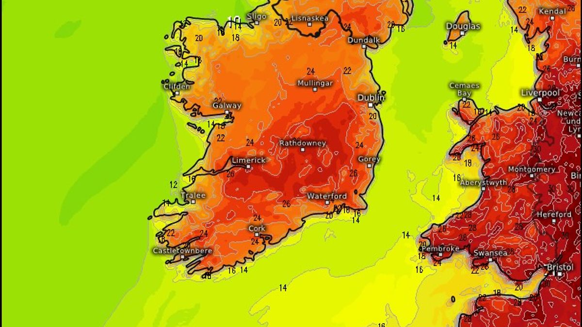
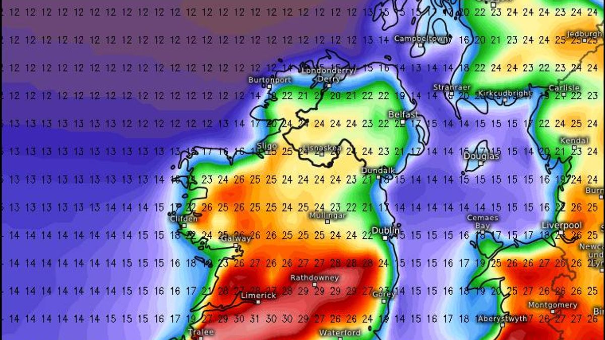
Record-breaking temperatures could be on the way to Ireland next week - as Dublin sizzles in 26C heat today.Temperatures in the capital will hit highs of 25 or 26C according to Weather Alerts Ireland, who say it will be "dry and sunny" across the country on this stunning Sunday. And we could be in for even higher temperatures tomorrow and Tuesday - with some forecast to be as high as 29C.They said: "Today will be a dry and sunny day for most (more in the way of cloud in Ulster and Connacht but clearing later in the day). Temperatures in Dublin reaching 25 or 26C."Tomorrow and Tuesday could be record-breaking as temperatures could rise as high as 29C, beating the previous May high in Kerry of 28.4C. Warmest in the midlands tomorrow and midlands and west for Tuesday."The highest recorded temperature in Ireland ever is 33.3C, which was measured at Kilkenny Castle on June 26, 1887. Met Eireann agree with the overall sentiment, though they are a little more conservative in their temperature estimates.Their forecast for today in Dublin reads: "Today will be warm and dry with sunny spells. Highest temperatures of 22 to 24 degrees with a light to moderate south to southwest breeze. Tonight will be dry and clear. Lowest temperatures of 12 or 13 degrees with light and variable winds."And here is what the rest of their forecast currently says for next week:Overview: Warm or very warm with plenty of sunshine at first. Temperatures will decrease later in the week, with showers becoming a possibility.Monday: Tomorrow will be dry, sunny and very warm. Highest temperatures of 25 to 27 degrees in a light southerly or variable breeze.Monday night: Cloud and patches of drizzle in the north and west but dry with long clear spells elsewhere. Mist and fog will form overnight in light northerly or variable winds. Lowest temperatures of 10 to 15 degrees.Tuesday: Mist and fog will clear during Tuesday morning. It will be dry and although some cloud will affect the northern half of the country at times, there will be plenty of warm or very warm sunshine overall. Highest temperatures of 20 to 27 degrees generally, warmest in Munster, although it will be cooler than this along north-facing coasts. Winds will be light to moderate and northerly or easterly in direction.Tuesday night: Dry with long clear spells. Patches of mist and fog will develop in the south. Lowest temperatures ranging between 7 degrees in the north and 15 degrees in the southwest, in a light to moderate east to northeast breeze.Wednesday: A few showers may develop in the southwest, but otherwise it will be a dry and warm day with plenty of sunshine. Highest temperatures of 20 to 26 degrees, warmest in Munster, with a light to moderate easterly breeze.Wednesday night: Most areas will stay dry and clear on Wednesday night. However, showers are possible in southern areas. Very mild overnight with temperatures not falling below 12 to 16 degrees, with a light to moderate east to southeast wind.Thursday: There is a possibility of some showers on Thursday, but these will be mixed with warm sunny spells. Highest temperatures of 18 to 24 degrees with a light to moderate south to southeast breeze.Further outlook: Current indications suggest that it will become less warm for the end of the week and into the Bank Holiday weekend, with showers and rain possible.Want to see more of the stories you love from Dublin Live? Making us your preferred source on Google means you’ll get more of our exclusives, top stories and must-read content straight away. To add Dublin Live as a preferred source, simply click here.Join our Dublin Live breaking news service on WhatsApp. Click this link to receive your daily dose of Dublin Live content.We also treat our community members to special offers, promotions, and adverts from us and our partners. If you don’t like our community, you can check out any time you like. If you’re curious, you can read our Privacy Notice.